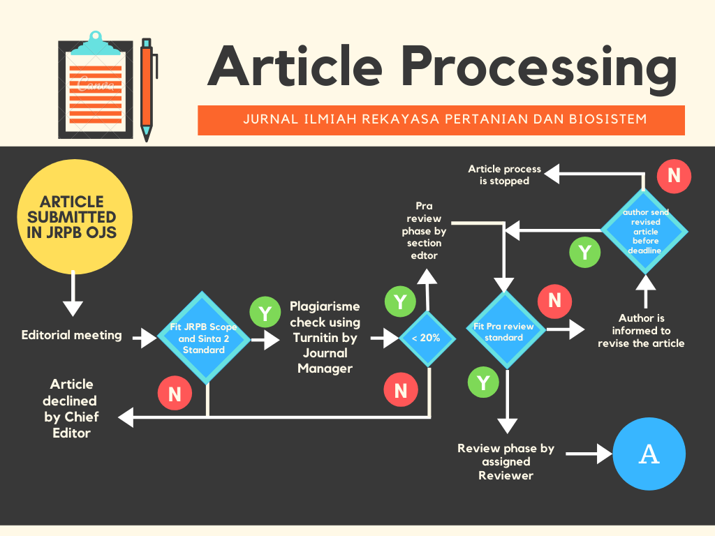
Suitability Land Evaluation for Durian Bawor in Banyumas Regency using GISBased IoT
Authors
Luthfi Wahab , Anri Kurniawan , Hanis Adila LestariDOI:
10.29303/jrpb.v13i1.1138Published:
2025-03-27Issue:
Vol. 13 No. 1 (2025): Jurnal Ilmiah Rekayasa Pertanian dan BiosistemKeywords:
banyumas, durian bawor, GIS, IoT, Land SuitabilityArticles
Downloads
How to Cite
Downloads
Abstract
Durian, known as the "King of Fruits," is a prevalent fruit in Indonesia, thriving in the tropical climate of Southeast Asia. One of the most widely cultivated varieties is Bawor, commonly found in Banyumas Regency, Central Java, producing 95,426 quintals in 2024. The price of Bawor durians ranges between Rp. 85,000 to Rp. 120,000 per fruit, weighing between 2 to 4 kg. Durian grows optimally in lowland areas up to 180 meters above sea level, with a humid climate, air temperatures of 25-32°C, humidity levels of 50-80%, and sunlight intensity of 45-50%. The research aims to build an information system called "SiDurIoT" based on the Internet of Things (IoT) integrated with a Geographic Information System (GIS) to evaluate the suitability of Bawor durian land. Land evaluation is classified S1, S2, S3, and N. Durian Information System with Internet of Things "SiDurIoT" is a device designed to measure the suitability of durian orchards in real-time. The device consists of a DHT22 sensor, a wind speed sensor, and GPS connected to the ESP32, with data displayed on an LCD screen. The device is connected to the internet via the website siduriot.my.id and the "SiDurIoT" smartphone application, which allows users to input measurement data. The results of the land suitability assessment show that wind speed, rainfall, soil pH, soil temperature, and land elevation are highly suitable (S1). In contrast, air temperature is suitable (S2), and humidity and sunlight intensity are marginally suitable (S3). Based on the suitability evaluation, the Kemranjen, Sumpiuh and Tambak areas are the most suitable locations for durian plantations because they have productivity above 10,000 quintals and are very suitable (S1).
References
Abu, N. S., Bukhari, W. M., Ong, C. H., Kassim, A. M., Izzuddin, T. A., Sukhaimie, M. N., Norasikin, M. A., & Rasid, A. F. A. (2022). Internet of Things Applications in Precision Agriculture: A Review. Journal of Robotics and Control (JRC), 3(3), 338–347. https://doi.org/10.18196/jrc.v3i3.14159 DOI: https://doi.org/10.18196/jrc.v3i3.14159
Adrian, Widiatmaka, Munibah, K., & Firmansyah, I. (2022). Evaluate land suitability analysis for rice cultivation using a GIS-based AHP multi-criteria decision-making approach: Majalengka Regency, West Java Province. IOP Conference Series: Earth and Environmental Science, 1109(1). https://doi.org/10.1088/1755-1315/1109/1/012062 DOI: https://doi.org/10.1088/1755-1315/1109/1/012062
Alazzai, W. K., Abood, B. S. Z., Al-Jawahry, H. M., & Obaid, M. K. (2024). Precision Farming: The Power of AI and IoT Technologies. E3S Web of Conferences, 491. https://doi.org/10.1051/e3sconf/202449104006 DOI: https://doi.org/10.1051/e3sconf/202449104006
Badru, L., Twaib, S., Oguti, V., Bongomin, O., & Ocen, G. G. (2022). Landslides Mapping and Design of IoT-based Susceptibility Prediction System: A Case Study of Bududa District in Uganda. ResearchSquare, 1–17. https://doi.org/10.21203/rs.3.rs-1370941/v1 DOI: https://doi.org/10.21203/rs.3.rs-1370941/v1
Basuki, B., Mandala, M., Bowo, C., & Fitriani, V. (2022). Evaluation of the suitability of a sugarcane plant in mount argopura’s volcanic land using a geographic information system. Jurnal Ilmiah Rekayasa Pertanian Dan Biosistem, 10(1), 145–160. https://doi.org/10.29303/jrpb.v10i1.315 DOI: https://doi.org/10.29303/jrpb.v10i1.315
Bazargani, J. S., Sadeghi-Niaraki, A., & Choi, S. M. (2021). A survey of gis and iot integration: Applications and architecture. Applied Sciences (Switzerland), 11(21). https://doi.org/10.3390/app112110365 DOI: https://doi.org/10.3390/app112110365
BPS Banyumas. (2024). Kabupaten Banyumas Dalam Angka 2024. In E. Budhia (Ed.), BPS Kabupaten Banyumas (2024th ed., Vol. 49, pp. 120–129). BPS Kabupaten Banyumas.
Dewantara, R., & Azis, D. (2021). Evaluasi Kesesuaian Lahan Perkebunan Tembakau Di Kabupaten Aceh Tengah Menggunakan Analisis Sistem Informasi Geografis. Jurnal Pendidikan Geosfer, 6(1), 27–35. https://doi.org/10.23701/jpg.v%vi%i.22099 DOI: https://doi.org/10.24815/jpg.v6i1.22099
Fauzi, F. R., Abdullah, S. H., & Priyati, A. (2018). Evaluasi Kesesuaian Lahan untuk Komoditas Padi dengan Memanfaatkan Aplikasi Sistem Informasi Geografis (SIG) di Kabupaten Lombok Tengah. Jurnal Ilmiah Rekayasa Pertanian Dan Biosistem, 6(2), 131–140. https://doi.org/10.29303/jrpb.v6i2.87 DOI: https://doi.org/10.29303/jrpb.v6i2.87
Hartanto, R., Arkeman, Y., Hermadi, I., Sjaf, S., & Kleinke, M. (2019). Intelligent Unmanned Aerial Vehicle for Agriculture and Agroindustry. IOP Conference Series: Earth and Environmental Science, 335(1). https://doi.org/10.1088/1755-1315/335/1/012001 DOI: https://doi.org/10.1088/1755-1315/335/1/012001
Jawaharlalnehru, A., Sambandham, T., Sekar, V., Ravikumar, D., Loganathan, V., Kannadasan, R., Khan, A. A., Wechtaisong, C., Haq, M. A., Alhussen, A., & Alzamil, Z. S. (2022). Target Object Detection from Unmanned Aerial Vehicle (UAV) Images Based on Improved YOLO Algorithm. Electronics (Switzerland), 11(15), 1–16. https://doi.org/10.3390/electronics11152343 DOI: https://doi.org/10.3390/electronics11152343
Lanya, I., & Manalu, T. J. (2021). Remote sensing and GIS application for mapping data base of sustainable agriculture land in Denpasar City. IOP Conference Series: Earth and Environmental Science, 648(1). https://doi.org/10.1088/1755-1315/648/1/012003 DOI: https://doi.org/10.1088/1755-1315/648/1/012003
Maroeto, Fauzi, A., Santoso, W., Siswanto, Idhom, M., & Priyadharsini, R. (2022). Assessment of Land Suitability Evaluation for Plantation Crops Using AHP-GIS Integration in the Wonosalam Forest Area, East Java. Universal Journal of Agricultural Research, 10(5), 569–586. https://doi.org/10.13189/ujar.2022.100512 DOI: https://doi.org/10.13189/ujar.2022.100512
Mugiyo, H., Chimonyo, V. G. P., Sibanda, M., Kunz, R., Masemola, C. R., Modi, A. T., & Mabhaudhi, T. (2021). Evaluation of land suitability methods with reference to neglected and underutilised crop species: A scoping review. Land, 10(2), 1–24. https://doi.org/10.3390/land10020125 DOI: https://doi.org/10.3390/land10020125
Muliasari, A. A., Wassahua, Z., Meliala, M. G., Sartika, I., & Septian, R. (2023). Coffee Land Mapping Using Unmanned Aerial Vehicles (UAVs) Multispectral Remote Sensing. Universal Journal of Agricultural Research, 11(6), 1077–1088. https://doi.org/10.13189/ujar.2023.110615 DOI: https://doi.org/10.13189/ujar.2023.110615
Nungula, E. Z., Mugwe, J., Massawe, B. H. J., Seleiman, M. F., Ali, N., & Gitari, H. I. (2024). GIS-AHP based approach in land evaluation and suitability assessment for sunflower (Helianthus annus) production. Cogent Food and Agriculture, 10(1), 1–22. https://doi.org/10.1080/23311932.2024.2309831 DOI: https://doi.org/10.1080/23311932.2024.2309831
Puttinaovarat, S., Saeliw, A., Kongcharoen, J., Pruitikanee, S., Pengthorn, P., Ketkaew, A., & Khaimook, K. (2024). Mobile Web Application for Durian Orchard Management and Geospatial Data Visualization Using Deep Learning. TEM Journal, 1837–1848. https://doi.org/10.18421/tem133-12 DOI: https://doi.org/10.18421/TEM133-12
Roslin, N. A., Che’ya, N. N., Rosle, R., & Ismail, M. R. (2021). Smartphone Application Development for Rice Field Management Through Aerial Imagery and Normalised Difference Vegetation Index (NDVI) Analysis. Pertanika Journal of Science and Technology, 29(2), 809–836. https://doi.org/10.47836/pjst.29.2.07 DOI: https://doi.org/10.47836/pjst.29.2.07
Ryandi, A. D., Budiono, N., & Rif’an, M. (2022). Evaluation of Land Suitability for Durian (Durio zibethinus), Mango (Mangifera indica), and Banana (Musa sp.) Cultivation in Banyumas Regency ARTICLE INFO ABSTRACT. Open Soil Science and Environment, 01(01), 35–49. soilenvironment.com
Saputra, M. F., Adyatma, S., & Arisanty, D. (2021). Evaluasi Kesesuaian Lahan Untuk Tanaman Durian Menggunakan Metode Matching. Jambura Geoscience Review, 3(1), 18–31. https://doi.org/10.34312/jgeosrev.v3i1.5652 DOI: https://doi.org/10.34312/jgeosrev.v3i1.5652
Sariani, S., Saida, S., Boceng, A., & Katili, H. A. (2023). Evaluasi Lahan Sebagai Dasar Pengembangan Tanaman Buah-Buahan Unggulan Di Kecamatan Tinangkung Selatan Kabupaten Banggai Kepulauan. Savana Cendana, 8(01), 18–24. https://doi.org/10.32938/sc.v8i01.1979 DOI: https://doi.org/10.32938/sc.v8i01.1979
Silalahi, A. V., & Rosyadi, R. I. (2024). Evaluasi Kesesuaian Lahan Kopi Robusta (Coffea canephora) Desa Pucaksari Kecamatan Busungbiu Kabupaten Buleleng Menggunakan Analisis Sistem Informasi Geografi. SPATIAL: Wahana Komunikasi Dan Informasi Geografi, 24(1), 21–30. https://doi.org/https://doi.org/10.21009/spatial.241.003 DOI: https://doi.org/10.21009/spatial.241.003
Sinchana, G. S., Choodarathnakara, A. L., & Arpitha, G. A. (2023). A Review on Land Suitability Mapping Using Geospatial Technology. The Mysore Journal of Agricultural Sciences Mysore J. Agric. Sci, 57(3), 55–79.
Taiyeb, A. (2023). Kesesuaian Lahan Bagi Pertumbuhan Durian (Durio zibethinus Murr.) di Desa Parisan Agung Kecamatan Dampelas Kabupaten Donggala. Agroland: Jurnal Ilmu-Ilmu Pertanian, 30(2), 136–146. https://doi.org/10.22487/agrolandnasional.v30i2.1711 DOI: https://doi.org/10.22487/agrolandnasional.v30i2.1711
Tehrani, F. S., Calvello, M., Liu, Z., Zhang, L., & Lacasse, S. (2022). Machine learning and landslide studies: recent advances and applications. Natural Hazards, 114(2), 1197–1245. https://doi.org/10.1007/s11069-022-05423-7 DOI: https://doi.org/10.1007/s11069-022-05423-7
Thereza, N., Saputra, I. P. A., & Husin, Z. (2021). Rancang Bangun Geographic Information System (GIS) Sebagai Pengembangan Sistem Monitoring Area Perkebunan Berbasis IoT. Jurnal Teknokompak, 15(1), 40–54. https://doi.org/https://doi.org/10.33365/jtk.v15i1.908 DOI: https://doi.org/10.33365/jtk.v15i1.908
Thirugnanam, H., Uhlemann, S., Reghunadh, R., Ramesh, M. V., & Rangan, V. P. (2022). Review of Landslide Monitoring Techniques With IoT Integration Opportunities. IEEE Journal of Selected Topics in Applied Earth Observations and Remote Sensing, 15, 5317–5338. https://doi.org/10.1109/JSTARS.2022.3183684 DOI: https://doi.org/10.1109/JSTARS.2022.3183684
Wahyu W, A., Ngadisih, N., Setyawan, C., & Khoiru Zaki, M. (2023). Spatial Multi Criteria Evaluation Dan Weighted Linear Combination Untuk Evaluasi Kesesuaian Lahan Kakao: Kasus Desa Nglanggeran - Daerah Istimewa Yogyakarta. Jurnal Ilmiah Rekayasa Pertanian Dan Biosistem, 11(1), 102–112. https://doi.org/10.29303/jrpb.v11i1.438 DOI: https://doi.org/10.29303/jrpb.v11i1.438
Worku, D., Boja, A., & Fantu, A. (2024). Evaluation of land suitability areas for irrigation using GIS and AHP-based tools in the case of Zenti River Catchment, Gofa district, Ethiopia. Cogent Engineering, 11(1), 1–17. https://doi.org/10.1080/23311916.2024.2345519 DOI: https://doi.org/10.1080/23311916.2024.2345519
Yusianto, R., Marimin, Suprihatin, & Hardjomidjojo, H. (2020). IoT Based Smart Agro-Industrial Technology With Spatial Analysis. Jurnal Teknologi Industri Pertanian, 30(3), 319–328. https://doi.org/10.24961/j.tek.ind.pert.2020.30.3.319 DOI: https://doi.org/10.24961/j.tek.ind.pert.2020.30.3.319
Zhu, Y., Zhou, J., Yang, Y., Liu, L., Liu, F., & Kong, W. (2022). Rapid Target Detection of Fruit Trees Using UAV Imaging and Improved Light YOLOv4 Algorithm. Remote Sensing, 14(17), 1–18. https://doi.org/10.3390/rs14174324 DOI: https://doi.org/10.3390/rs14174324
License
Copyright (c) 2025 Luthfi Wahab, Anri Kurniawan, Hanis Adila Lestari

This work is licensed under a Creative Commons Attribution-ShareAlike 4.0 International License.
Authors who publish with this journal agree to the following terms:
- Authors retain copyright and grant the journal right of first publication with the work simultaneously licensed under a Creative Commons Attribution License 4.0 International License (CC-BY-SA License). This license allows authors to use all articles, data sets, graphics, and appendices in data mining applications, search engines, web sites, blogs, and other platforms by providing an appropriate reference. The journal allows the author(s) to hold the copyright without restrictions and will retain publishing rights without restrictions.
- Authors are able to enter into separate, additional contractual arrangements for the non-exclusive distribution of the journal's published version of the work (e.g., post it to an institutional repository or publish it in a book), with an acknowledgement of its initial publication in Jurnal Ilmiah Rekayasa Pertanian dan Biosistem (JRPB).
- Authors are permitted and encouraged to post their work online (e.g., in institutional repositories or on their website) prior to and during the submission process, as it can lead to productive exchanges, as well as earlier and greater citation of published work (See The Effect of Open Access).